AIS on your Android or iPhone
AIS is intended, primarily, to allow ships to view marine traffic in their area and to be seen by that traffic.
This requires a dedicated VHF AIS transceiver that allows local traffic to be viewed on an AIS enabled chartplotter. This is usually very expensive since a high end chartplotter can cost tens of thousands of dollars.
Now you can get a high end AIS chart plotter experience using i-Boating, an extremely popular marine navigation app on iOS, Android & Windows. It supports connecting to AIS receivers directly as well as via NMEA routers and track all nearby AIS targets.
![]()
How AIS works?
AIS transceivers automatically broadcast information, such as their position, speed, and navigational status, at regular intervals via a VHF transmitter built into the transceiver.
The information originates from the ship’s navigational sensors, typically its global navigation satellite system (GNSS) receiver and gyrocompass. Other information, such as the vessel name and VHF call sign, is programmed when installing the equipment and is also transmitted regularly. The signals are received by AIS transceivers fitted on other ships or on land based systems, such as VTS systems. The received information can be displayed on a screen or chart plotter, showing the other vessels’ positions in much the same manner as a radar display. Data is transmitted via a tracking system which makes use of a Self-Organized Time Division Multiple Access (SOTDMA) datalink designed by Swedish inventor Håkan Lans.
i-Boating step by guide for using AIS
- Connect your phone/table to the onboard wifi network/wifi network setup by your AIS receiver. Note that this step needs to happen outside the app.
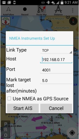
- Press menu/overflow button and select “Start AIS” and enter the following details:
You would have to refer to your AIS receiver manual to get the exact values. The application supports NMEA over both TCP & UDP. Here is a screenshot for how this looks like.

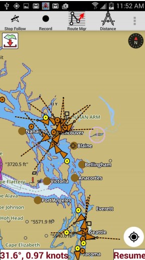
AIS display
- The app support automatic age-ing of targets. The targets would turn grey if no messages are received for that target for 5 minutes. You can adjust this interval in AIS setup when you start AIS.
- The targets are color coded. Class A Targets are orange, Class B targets are dark pink, Base station targets are green, ATONs are purple, SART are red and everything else is yellow.
- If the heading is available, then the target is drawn with the heading vector drawn on the map.
- Tapping on a target would display all info about the target (including static info such as name, ETA, destinatin, MMSI etc.).
- Static AIS messages are sent less frequently than dynamic AIS messages. So static info about a target make take a little longer to become available.


